Friday, December 10, 2010

Autocomplete

In the world of auto complete being a part of our internet searches, and often times messages sent from our phones, A blogger named Dorthy has made a map of the united states, allowing Google to fill in the rest.


Another blogger named Arnab has taken it a step further, and has created a program that will constantly update a version of this same map! Check it out here!

Wednesday, November 17, 2010

Third Thursday, Tomorrow!

Its that time again! The Map Library is having its monthly exhibit tomorrow from 4 to 7, displaying maps of and about Indigenous Cultures!
And we are still doing our Travel and Road map sale tomorrow as well, get some fascinating maps for pocket change!

Wednesday, November 10, 2010

New Map Aquisition!

The Map library has recently been gifted a wonderful addition to our French map collection. The generous William Heidrich has purchased for us the rare and exceptional 18th century Claude Roussel Nouveau Plan de Paris.


"The Roussel piece is a magnificent wall plan of Paris that thoroughly maps the city and provides visual depictions of its iconic structures. The 37 vignettes that surround the map illustrate the city’s well- and lesser-known architectural triumphs, including palaces, major administrative buildings, gardens, and arches. Also among the vignettes are a small panoramic view of the city, and another of the Pont Royal."

For more information click here.

With new technology comes new dilemas.

Many of us have heard about someone using heir GPS being told to drive into a pond, or onto a road that doesn't exist, but what about a virtual glitch that causes an invasion?

Last week Nicaragua accidentally invaded Costa Rica due to Google maps representation of the border lines being wrong.

The image below supplied by SearchEngineLand shows the difference.


While most that have used Google maps before for a road trip know enough not to trust them explicitly, it seems Nicaragua has learned the hard way!

Wednesday, October 20, 2010

Map sale and Third Thursday event tomorrow!

Everyone is invited to check out this months Third Thursday Event, City Maps!
Tomorrow evening from 4-7 pm the Hatcher Graduate Map Library, on the 8th floor, will be featuring our unique city maps for all to see, Student, Faculty and Public alike. After you have wandered through our display ( or before, the map sale is all day long!) , pick up a few maps next door from our Map Sale! Due to a sudden surplus of duplicate maps we have many to sell, from local maps of the area to maps from all over the world. We even will have a couple globes for sale too! Most maps will be only a dollar so stock up a couple for your car, one for your bare wall in your new space and another of lands you one day would like to see first hand. Not only will we have maps and atlas's for sale, but this time we will also have language tapes as well!

Friday, October 08, 2010

Map Art

While old maps are usually seen as art work more than for their usefulness, but here we have a new artist proving otherwise. She has shown that modern maps can be seen as an intricate pieces of art that extend past their usefulness becoming a thing of interest beyond getting from a to b.


An artist in North Carolina, Karen M. O'leary, has been making intricate paper cutting of maps of cities from all over the world. Below is a beautiful example of Mexico City which is available to purchase.


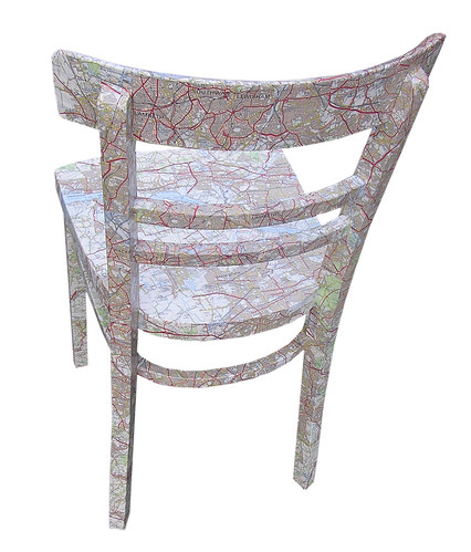
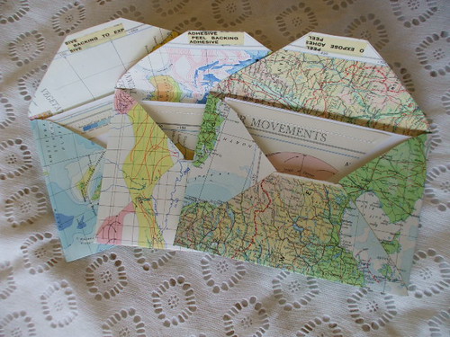
With truly impressive amounts of patience these gorgeous works of art are for sale via her etsy page, but are also browesable via her flickr page for those who would like to appreciate the rest of her work.


Thursday, September 23, 2010

Global Climate Maps


Because many developing countries do not have the technology to study in depth the amount of air pollution affecting its citizens NASA has taken it upon themselves to make a global map showing areas of higher and lower density of pollution.

Our map library has many maps similar to this as well in our vast collection!

Wednesday, September 22, 2010

Race and ethnicity: Detroit

Eric Fisher has created race and ethnicity maps based on census data of many major cities around the United States, with the end result being almost artistic.

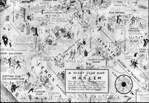
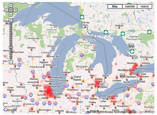
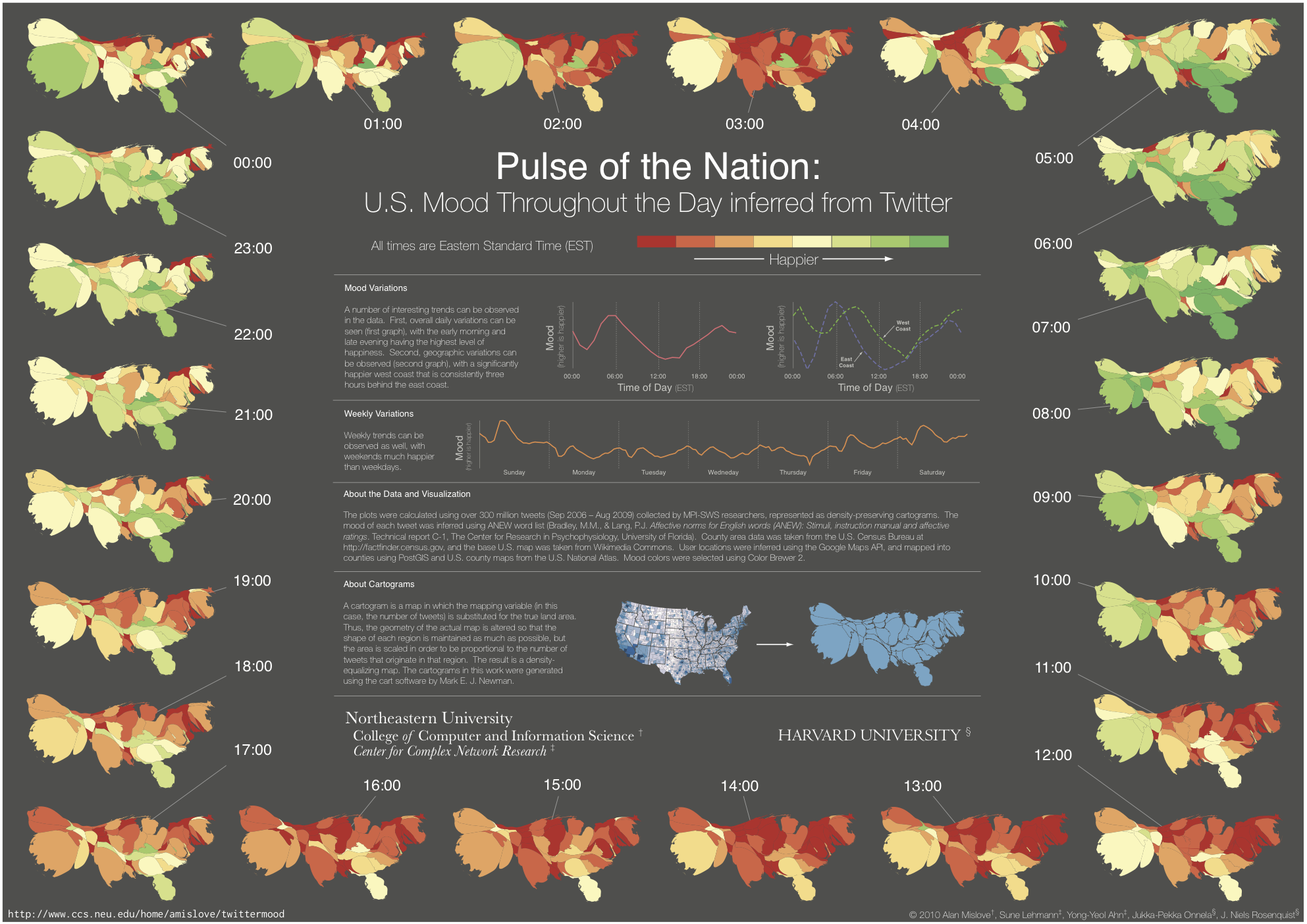
By clicking on the image you are able to see tagged locations, and even some explanations of the divide in Detroit.
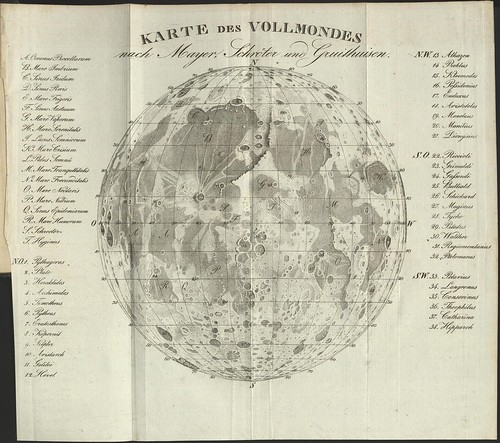
Detroit not your nearest hub? No problem! Click here to view other cities.

Thursday, September 16, 2010

Map Sale and the first Third Thursday of the Semester!

just-box paris

All Maps one dollar unless marked with globes and atlas's for sale as well. All duplicates from a recent donation. Perfect for a wall hanging a collage, or any other projects to enhance your life.

Did you just move in and have an empty space on your wall? A map is the perfect filler of space, filled with information and appealing to the eye as well. Do you need to refresh your furniture? Perhaps a few maps for decoupaging is just what the doctor ordered like this chair done by Bombus Designs
Map chair behind

or maybe a few fancy envelopes like RingAroundTheMoon has made?


So wander by this evening and ask about our duplicates and stay to check out the maps!

Thursday, September 02, 2010

Did you know? Not all maps are of earth.

In 1829 this detailed map made by ML Frankheim was published in Popular Astronomy

Karte des Vollmondes nach Mayer, Schroter und Guithuisen - Popular Astronomy by ML Frankheim, 1829, Braunschweig (SLUB) via Peacay

The mapping of objects other than the earth started well before we were able to actually take photographs of surfaces.

Thursday, August 19, 2010

Donations!

The donations are STILL rolling in, keeping those at the map library quite busy. This batch was actually taller than one of the interns.


With many more maps, globes ( stuffed and otherwise), and atlas's there are plans for a map sale in the near future. Keep your eyes and ears open for the announcement!

A night on the town in Harlem, In the 1930's of course.

While Harlem may not be thought of as the place to go for a bit of night entertainment for all, but in the 1930's it was the a hopping and significant center for Jazz clubs. Click the Image for a closer look.
A Nightclub Map of Harlem
via Mike_Thibault

Monday, August 02, 2010

Got Spam?


Like a majority of the population when spam appears in our inbox we delete it or send it to the spam folder with no regard for what message it holds, perhaps getting a chuckle out of he subject.
But have you ever wondered where it originated from? Thanks to the all knowing power of google you can peruse a map of malicious ip addresses and see that maybe... just maybe it could be someone next door in your little town filling your inbox with advertisements for special enhancers.
malicious ip address map- Michigan
Check it out for yourself here.

Thursday, July 29, 2010

What would the earth look like if it stood still?

Well with the help of ArcGIS (which we have for use at the map library) we can see.

Through predicting how the changes in gravity would change the water masses and where they would settle.
Michigan would not only be great lake-less we would also be a part of the newly formed oceans!

To read up more, the full article here.

Friday, July 23, 2010

What is new this week? Well...


This week consisted of moving furniture. ( We have a wonderful new reference desk!)
And going through quite a large donation to weed out duplicates and giving nearly every item a wipe down. The boxes were kept in a garage, many maps were musty, a handful moldy and worst of all a few had been affected by mice in various ways, altogether a messy job.

Like most moves this process is messy too,
but in the end ( well near end...) it looks new, updated and results in many comments on the layout.


ref desk

The change has been a success with new patrons going to the actual reference desk rather than weeble wobbling between the desks in an attempt to grab the right persons attention.

What do you think?

Thursday, July 22, 2010

How happy is the nation?

A recent study by researchers from Northeastern University and Harvard University of twitter data has given us an interesting look into the nations moods. With a simple idea in mind we are able to see how moods fluctuate of those who tweet over a 24 hour period. Words are given a rating, Happy or sad and with the resulting data the scientists were able to see how moods naturally fluctuated in zones through out the day and through out the week. Sundays are a high point for most, with Thursday being the down point in the week pointing to the 5 day work week of many.

Wednesday, July 21, 2010

Where are the trees?


NASA, in an attempt to see where " missing" Carbon goes and if our forests can handle the amount we are pushing out every day, has taken a scan of our world and as a result we have a detailed Map of Global Forest Heights. The map is a first of its kind, showing the whole world in one scan giving the relative canopy height of the forests.


Wednesday, July 14, 2010

Hello!

Welcome to the University of Michigan's Map Library Blog.

From here on out regular updates will be made of events happening in the area, interesting articles, images, and updates to our collection.

To start off currently in the Audubon Room from now until September 20th from 8:30- 7 there is an exhibit entitled " Tour de France: Travel & Topography in France 1700-1900". This exhibit allows us to shows off some of our more interesting and rare French maps to the public over a long time frame, a collection that most who visit the map library would not know about.

Come and visit today!